Mt. Outram
August 24-25, 1998
Mt. Outram is described by Fred Beckey as having "the finest assortment of
arctic flora in the northern Cascades" - quite a claim, but made by someone
who should know. This peak had been recommended to me during a swap of
favorite climbing destinations on the top of Mount Dickerman a couple of years
back, so this August Maren and I made the trip up to British Columbia to try it
ourselves. The trail data sounded good - 6000 feet of elevation gain in 5 miles,
and a class 3 scramble to the true summit at 8000+' (although we learned later
that the trail had been regraded in 1989, and was now all of 5.5 miles (the
6000' vertical hadn't changed!) - still a steep little puppy!).
 Although the peak is in Canada, the trailhead is just off of the Trans-Canada
Highway, allowing us to make the drive from Seattle in just 3 hours - no
longer than it takes to reach many of the peaks north of Mt. Baker. The trail
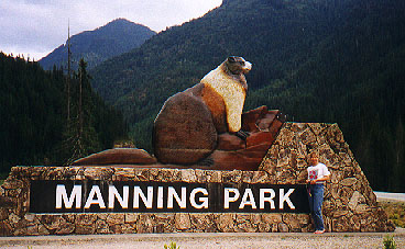
takes off from the parking lot at the western entrance to Manning Provincial
Park - it's hard to miss, with the statue of the giant marmot looking over the
highway. Although I gather this is a fairly popular summit, there is no
official trailhead sign here - instead, start out on the trail marked
"Engineer's Road Loop - 20 minutes". This trail switchbacks twice in forest,
then brings you out on the old engineer's road. There is a sign here, but it
still has no reference to Mt. Outram. Turn right, and follow the old road for
a few minutes, crossing a surprising amount of small blowdown. Up to this
point I wasn't convinced we were heading in the right direction, but shortly
after the blowdown you come to a trail heading north, and the trailhead marker
there finally confirms that you're on the Mt. Outram trail. The start of the
trail wanders pleasantly through forest for the first few hundred yards, then
starts to get steep. Ridiculously steep! The payoff for the grade, however, is
that you reach the high alpine country that much more quickly.
Although the peak is in Canada, the trailhead is just off of the Trans-Canada
Highway, allowing us to make the drive from Seattle in just 3 hours - no
longer than it takes to reach many of the peaks north of Mt. Baker. The trail
takes off from the parking lot at the western entrance to Manning Provincial
Park - it's hard to miss, with the statue of the giant marmot looking over the
highway. Although I gather this is a fairly popular summit, there is no
official trailhead sign here - instead, start out on the trail marked
"Engineer's Road Loop - 20 minutes". This trail switchbacks twice in forest,
then brings you out on the old engineer's road. There is a sign here, but it
still has no reference to Mt. Outram. Turn right, and follow the old road for
a few minutes, crossing a surprising amount of small blowdown. Up to this
point I wasn't convinced we were heading in the right direction, but shortly
after the blowdown you come to a trail heading north, and the trailhead marker
there finally confirms that you're on the Mt. Outram trail. The start of the
trail wanders pleasantly through forest for the first few hundred yards, then
starts to get steep. Ridiculously steep! The payoff for the grade, however, is
that you reach the high alpine country that much more quickly.
As you climb, you have the opportunity to look south into the North Cascades -
Mt. Redoubt crowns the views from here, standing high above anything else
south of Mt. Outram. The last running water we came across was around 5900',
where the trail crosses a pretty little stream. We stopped here and filled our
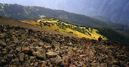
water bottles, not sure of the water supply higher up. We broke out of the
trees around 6000', and could see where the old route headed steeply up the
ridge we were on - thankfully, the new regrade took a sidehill switchback
here, going through flower meadows (sadly, past their prime this year) and
huckleberries galore. Around 6200' we finally found some flat terrain for
setting up our tent - there's a small tarn here that still had plenty of water
in it, which could have saved us a few pounds of water on the previous 700',
had we known for sure it wouldn't be dry.
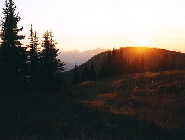
Sunset this day was just after 8:00,
and moonset was at 9:30. With no clouds in the sky, the stars were spectacular
by the time the sunset glow had disappeared from the mountains.
 The next morning we headed towards the summit with light packs, following the
large orange arrows painted on the boulders of the scree field leading to the
summit shoulder. Now and then we'd pass a boulder with a large number painted
on it - it started with a 12, and then began a countdown. We eventually
figured out that they were letting us know how many hundreds of feet were left
to the summit (and we're concerned about a few bolts here and there)! It took
just over an hour to arrive at the false summit, with a wonderful bivy shelter
built of rocks perched on top of it. The summit register was here as well, but
the Beckey guide stated that the small summit just north of here was the true
summit. Up to this point the "climb" had just been a steep walk - to get to
the true summit, however, necessitated scrambling down about 30 feet into an
erosion dyke, up the other side, then down another 30 feet into a second dyke
and up to the true summit, all accomplished easily, but carefully. By the time
we stood on the summit, some clouds had started blowing in from the south and
east, and robbed us of what would undoubtedly have been glorious views. None
the less, we admired the small hanging valley on the west flank of the
mountain, and had peek-a-boo views down the NE ridge route, and the remnants
of the glacier dropping off the north side.
The next morning we headed towards the summit with light packs, following the
large orange arrows painted on the boulders of the scree field leading to the
summit shoulder. Now and then we'd pass a boulder with a large number painted
on it - it started with a 12, and then began a countdown. We eventually
figured out that they were letting us know how many hundreds of feet were left
to the summit (and we're concerned about a few bolts here and there)! It took
just over an hour to arrive at the false summit, with a wonderful bivy shelter
built of rocks perched on top of it. The summit register was here as well, but
the Beckey guide stated that the small summit just north of here was the true
summit. Up to this point the "climb" had just been a steep walk - to get to
the true summit, however, necessitated scrambling down about 30 feet into an
erosion dyke, up the other side, then down another 30 feet into a second dyke
and up to the true summit, all accomplished easily, but carefully. By the time
we stood on the summit, some clouds had started blowing in from the south and
east, and robbed us of what would undoubtedly have been glorious views. None
the less, we admired the small hanging valley on the west flank of the
mountain, and had peek-a-boo views down the NE ridge route, and the remnants
of the glacier dropping off the north side.
We headed back down to our campsite, running into one of only three people
we'd see on this climb. We ate a quick lunch before breaking camp, and chatted
with two other day hikers as they walked by our camp heading for the summit.
They were the ones who informed us that the trail had been regraded in 1989,
adding a half mile to the distance. I can only imagine what it must have been
like before the regrade! After breaking camp, we made our way (very slowly)
through the huckleberry fields, finally starting to put on a little speed as
the clouds that had been blowing in all morning started spitting a few rain
drops. All the way down we were reminded of how steeply we had climbed the day
before, and our thighs continued to remind us of this for the next couple of
days!
Last updated: April 3, 2001