Mt. Washington (I-90)
February 21, 1998
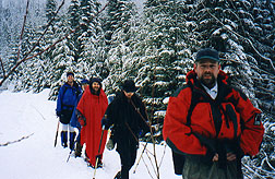
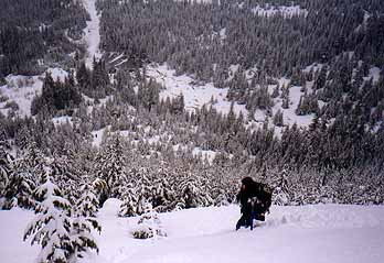
The weather was not promising blue skies and sunshine, but most of the folks who had signed up for this trip showed up at the appointed hour in Issaquah to head for the Mt. Washington trailhead. At the parking area we were greeted by rain and gray everywhere, with a few glimpses of snow higher up when there was a brief break in the clouds. Only slightly daunted, and our enthusiasm (and only our enthusiasm) undampened, we headed up from the cars to the old railroad grade, and on to the start of the trail.
 There is now a sign (very small, and very high up on a tree) indicating
that this is the "Mt. Wa." trail, but even before this sign
was up, the trail was hard to miss. Some of the damage done
by bringing in heavy equipment last spring to clear a major
log jam has been re-camoflaged by new growth, but the first
section of the trail is still very rocky. As we climbed up
past the climbing areas (Club Paradiso, The Actual Cave,
Chainsaw Bob's and the Peannacle), the clouds actually got
thinner, and for a while we had no precipitation falling on
us. Just before the creek crossing we passed a major blowdown
that has obscured part of the trail - stay close to the
creek, and you'll be back on the trail in 50 feet or so. By
the time we hit about 3000', the rain had turned to snow,
and there was a fair amount of snow on the ground. We
followed boot and snow shoe prints along the trail/creek bed
and eventually up onto an old logging road. Here, all the
prints headed east along the road grade, and the long route
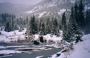
to the summit. We headed west past a small, frozen pond
There is now a sign (very small, and very high up on a tree) indicating
that this is the "Mt. Wa." trail, but even before this sign
was up, the trail was hard to miss. Some of the damage done
by bringing in heavy equipment last spring to clear a major
log jam has been re-camoflaged by new growth, but the first
section of the trail is still very rocky. As we climbed up
past the climbing areas (Club Paradiso, The Actual Cave,
Chainsaw Bob's and the Peannacle), the clouds actually got
thinner, and for a while we had no precipitation falling on
us. Just before the creek crossing we passed a major blowdown
that has obscured part of the trail - stay close to the
creek, and you'll be back on the trail in 50 feet or so. By
the time we hit about 3000', the rain had turned to snow,
and there was a fair amount of snow on the ground. We
followed boot and snow shoe prints along the trail/creek bed
and eventually up onto an old logging road. Here, all the
prints headed east along the road grade, and the long route
to the summit. We headed west past a small, frozen pond
 until we found a suitable slope to head directly summit-wards,
 cutting several miles off the standard route to the summit.
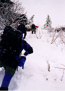
Urging the rest of the team to head up and kick me some
steps, we started gaining some elevation. The snow was soft
and deep, and it lies over a slash area, so there were
numerous and excellent examples of snow swimming and snow
floundering! We eventually made it up to a small plateau, and
then continued on into the tree bashing section of this
route. Fortunately, this section is short, but the trees are
short and stocky, and grow together so thickly there is no
way to go around them - you just have to put your head down
and push through (note: ponchos are not the ideal rain wear
for tree bashing!). The trees end at a short, steep wall of
snow that put us back up on the logging road again - we
followed this left and around a hairpin turn, then picked
another likely looking slope and climbed the last 100 or so
feet up to the summit.
cutting several miles off the standard route to the summit.
Urging the rest of the team to head up and kick me some
steps, we started gaining some elevation. The snow was soft
and deep, and it lies over a slash area, so there were
numerous and excellent examples of snow swimming and snow
floundering! We eventually made it up to a small plateau, and
then continued on into the tree bashing section of this
route. Fortunately, this section is short, but the trees are
short and stocky, and grow together so thickly there is no
way to go around them - you just have to put your head down
and push through (note: ponchos are not the ideal rain wear
for tree bashing!). The trees end at a short, steep wall of
snow that put us back up on the logging road again - we
followed this left and around a hairpin turn, then picked
another likely looking slope and climbed the last 100 or so
feet up to the summit.
 The winds were blowing the snow
horizontally (note: ponchos are not the ideal rain wear for
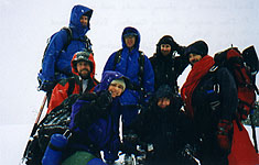
strong winds!), so after a quick summit picture we headed
west to the subsidiary, but tree sheltered, summit for a
quick bite of lunch. Realizing it wasn't going to get hot and
sunny any time soon, lunch was a hurried affair, after which
we all agreed it was time to head for the cars. We chose a
different slope to descend,
allowing for many more examples
of snow swimming and post holing before we reached the frozen
pond once again. Not content with the adventure so far, the
group allowed me to talk them in to trying a "short cut" from
the pond straight back down to the trail. While the route
certainly covered less distance, it forced us through much
more brush (and devil's club) than our meandering ascent
route. At one point, the brush was so thick, and the snow was
so thin, that I just started wading down the middle of the
creek to regain the trail - wet feet seemed better than
barked shins and devil's club spines! Once back on the trail,
the remaining descent was uneventful - the rain even let up
for a while. This wasn't an outing for great views, but it's
still a fun late winter/early spring route - I think everyone
had a good time!
The winds were blowing the snow
horizontally (note: ponchos are not the ideal rain wear for
strong winds!), so after a quick summit picture we headed
west to the subsidiary, but tree sheltered, summit for a
quick bite of lunch. Realizing it wasn't going to get hot and
sunny any time soon, lunch was a hurried affair, after which
we all agreed it was time to head for the cars. We chose a
different slope to descend,
allowing for many more examples
of snow swimming and post holing before we reached the frozen
pond once again. Not content with the adventure so far, the
group allowed me to talk them in to trying a "short cut" from
the pond straight back down to the trail. While the route
certainly covered less distance, it forced us through much
more brush (and devil's club) than our meandering ascent
route. At one point, the brush was so thick, and the snow was
so thin, that I just started wading down the middle of the
creek to regain the trail - wet feet seemed better than
barked shins and devil's club spines! Once back on the trail,
the remaining descent was uneventful - the rain even let up
for a while. This wasn't an outing for great views, but it's
still a fun late winter/early spring route - I think everyone
had a good time!
Last updated: April 3, 2001